World atlas of the Phillippe Vandermaelen testifies to archipelago sovereignty
Được xuất bản vào Thứ Sáu, 16/05/2014 - 09:50
(ICTPress) - The Ministry of Information and Communications has just received and announced World Atlas of the Phillippe Vandermaelen and its value in affirming Vietnam’s sovereignty over the archipelagoes on East Sea.
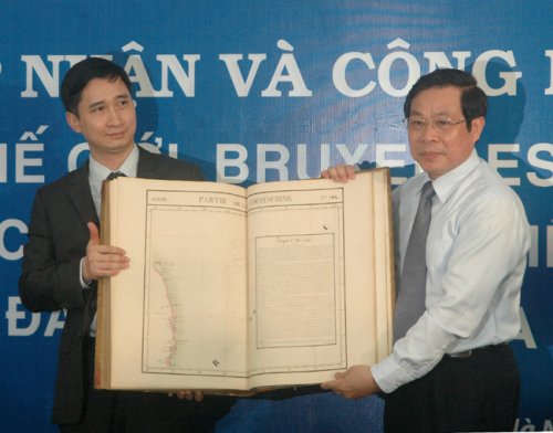 |
| Minister Nguyen Bac Son and CEO Ngo Chi Dung announced the World atlas of the Phillippe Vandermaelen in Hanoi in May 13, 2014 (Image: Minh Thien). |
The Ministry of Information and Communications has been aware of the importance of the document, purchased the atlas with support from Ngo Chi Dung, director of ECO Pharmaceutical Company.
Minister Nguyen Bac Son said when the World Atlas displayed to the public in Ha Noi to raise awareness about the nation's indisputable sovereignty.
Professor Nguyen Quang Ngoc from Ha Noi National University, vice chairman of the Vietnam Historical Science Association, found the maps at a bookstore in Belgium and have had many discussions with foreign scholars and experts that they also affirmed the value of the map.
 |
| Professor Nguyen Quang Ngoc prensented the valued information of the World Atlas (Image: Minh Thien) |
He also deliverd all valured information of the world Atlas to the audiences from many organizations gatherd in its announcing ceremony in Hanoi:
In 1827, Philippe Vandermaelen (1795 - 1869), the remarkable geographer, member of the Paris Geography Association, published the World Atlas that comprises 6 volumes with 7 general maps of five continents, 381 detailed maps, 40 pages of statistics and a lot of information on natural, political and mineral geography. The Atlas has been completed on the basis of the best world maps at that time, together with the information from astronomical observation or the voyages in a lot of places on earth and unanimously drawn in accordance with the 1/1641836 scale, dimension of 53,5X37cm, which can be pieced together into a globe of diameter of 7.755cm. This is really the great landmark marking the stage of overdeveloping of the modern technology of drawing and printing maps in early 19th Century. For nearly 200 years, the Atlas has become extremely famous, being exploited and used by a lot of countries in the world.
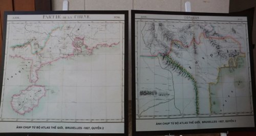 |
| The maps showed in Hanoi |
The Asian volume has 111 maps, mainly arranged in volume two of the Atlas. Vietnam was introduced at that time through the maps number 97,105, 106 and 110. Partie de la Cochinchine is the map 106 where the central coast line was drawn from the 12th Parallel to the 16th Parellel. In the high sea, Paracels (Hoàng Sa) was drawn in detail and preciseness from about the 16th latitude to the 17th latitude and from the 109th longitude to the 111th longitude. The Paracels archipelago in the map has Pattles and Duccan islands in the west; Tree and Lincol, Rocher au desus de l’eau in the east and Triton in the southwest, right below the 16th latitude; Investigateur is deep to the south at about 14.5th latitude. Apart from the area determined as the Paracels, the map has also another map which introduces in short the Empire of An Nam.
Next to the Partie de la Cochinchine, up above is the map number 98 with the name the Partie de la Chine in the 18th-21st latitude and the 106th-114th longitude which drew the Guangdong and Hainan, showing that China’s southernmost boundary is yet to touch the 18th latitude. All China’s maps from the decade of early 20th Century backwards also match fully the Western maps with no drawing of China’s southernmost territory beyond the 18th latitude. This not only reflects the objectivity and precision of the Atlas, but also makes a contribution to enhancing further the value that evidences of Vietnam’s sovereignty of the Paracels reflected in the Partie de la Cochinchine.
At the beginning of the 16th Century, there were some Western maps that drew the Eastern Indian area with marks of Paracels in the middle of East Sea and the coastal area in the west of Paracels (the coast of Central Vietnam) was marked Costa de Paracels (the Hoang Sa waters). Entering the 17th Century and particularly the 18th Century, a lot of maps reflected clearly the geographical position and characteristics and the sovereignty relations of the Paracels with the Đàng Trong region. However, most of these maps arranged the Paracels in the general East Indian region.
Only until early 19th Century when the Nguyen Dynasty was set up with the affirmation of Vietnam’s sovereignty in a complete manner, it really followed the principle of acquisition of territories by the Western recognition and praise, the Western map officially affirmed the Paracels archipelago lay within Vietnam’s territories and belonged to Vietnam. The Partie de la Cochinchine is the first map that mapped out in an absolutely precise manner the position (latitude and longitude), geographical characteristics, the Western name of the biggest and most important island in the Hoang Sa archipelago. The map placed in the Cochinchine region was an organic and inseparable part of Empire An Nam. It proves clearly and precisely Vietnam’s sovereignty over the internationally recognized Paracels.
The World Atlas of Philippe Vandermaelen in general and the Partie de la Cochinchine in particular can be considered in all aspects as the priceless document that not only raises the standard scientific value of the propaganda and education of sovereignty over islands and sea, but also is the convincing, true and effective evidence and international legal value for the struggle to defend the sacred sovereignty over islands and sea of the Fatherland of Vietnam.
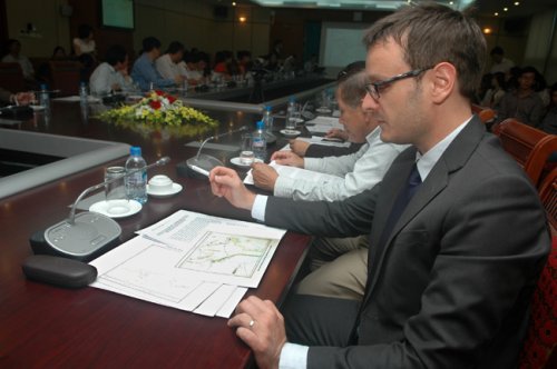 |
| A representative from French embassy in Hanoi saw the detailed maps. (Image: Minh Thien) |
Thanks to our colleagues in Paris, we can have the first information about the Atlas; on the other hand we are given conditions by the Ministry of Information and Communications to expand the exploitation of the sources of relevant information. Mr. Ngo Chi Dung, General Director of the ECO Pharmaceuticals Company has funded us to carry out the survey of 5 sets of Atlas in the national libraries in France and Belgium, the Geographical Library of Royal Belgium, the library of Paris University; to have discussion and unanimous assessment of the geographical experts, topographers, historians, lawyers and librarians in Paris and Bruxelles so as to be able to have the foundation to determine the World Atlas of the ancient Bookstore Sanderus, No. 32, Nederkouter, Gent City, Belgium, as the original in Bruxelles in 1827. After having important information, he decided to buy the complete set of 6 World Atlas to help make fuller historical and legal evidences concerning Vietnam’s sovereignty over the Paracels.
On the occasion that the Ministry of Information and Communications organized the ceremony to present and introduce this set of Atlas, we would like to express our thanks to all the organizations and individuals for their great efforts to have the presence of the World Atlas of Philippe Vandermaelen in Vietnam and it has officially become the national treasure of Vietnam.
It would like to say further that this Atlas has got the boundaries, the scope of territories and territorial waters which are clearly defined and easily recognized. If you find anything that needs explanation, you can quickly examine it on the website or directly study the originals in a lot of libraries and archives in Europe and America and now in Hanoi, Vietnam, Professor Ngoc said.
Here are the the reference links you can find in the Internet further approving the maps:
http://www.ubka.uni-karlsruhe.de/kvk/view-title/index. php? katalog=HEBIS&url= http%3a%2f%2fcbsopac.rz. uni-Frankfurt.de%3a80%2fDB%3d2.1%2fCHARSET % 3dUTF-8%2fIMPLAND%3dY%2fLNG%3dDU% 2fSRT%3dYOP%2fTTL%3d1%2fCOOKIE%3dU203%2cK203%2cI251%2cB1999%2b%2b%2b%2b%2b%2b%2cSN%2cNDefault%2blogin%2cD2.1%2cE145894ae-1%2cA%2cH%2cR129.13.130.211%2cFY%2fSET %3d1%2fSHW%3fFRST%3d5&showCoverImg=1./.
Xem thêm:

(ICTPress) - "Bộ Atlas được Bộ TT&TT tiếp nhận là bộ tài liệu quý góp phần khẳng định chủ quyền của Việt Nam đối với hai quần đảo Trường Sa và Hoàng Sa".
// Mới cập nhật


// Tin đã đăng